Directory of memorials to war dead and war gravesites
The Brandenburg register of memorials to fallen soldiers and war gravesites is an open project of the Brandenburg Genealogical Society "Roter Adler" e.V. Not only members of the society but also all other interested parties can participate. In this project, which is affiliated to the cemeteries as well as to the villages, monuments for fallen soldiers as well as war gravesites and the data to be found on them are to be recorded. It does not matter whether they are located in a cemetery or any other place in the village.
Each sender of data can decide for himself whether the transcripts are to be displayed completely publicly or only as an index of names. The symbols behind the war memorials and war gravesites have the following meaning: The transcripts for these entries can be viewed completely publicly./em>
 Information on these fallen soldiers or graves can be requested by e-mail
Currently this directory contains information on 1191 war memorials and war gravesites.
Berlin Karlshorst Gelände der Trabrennbahn WK 1
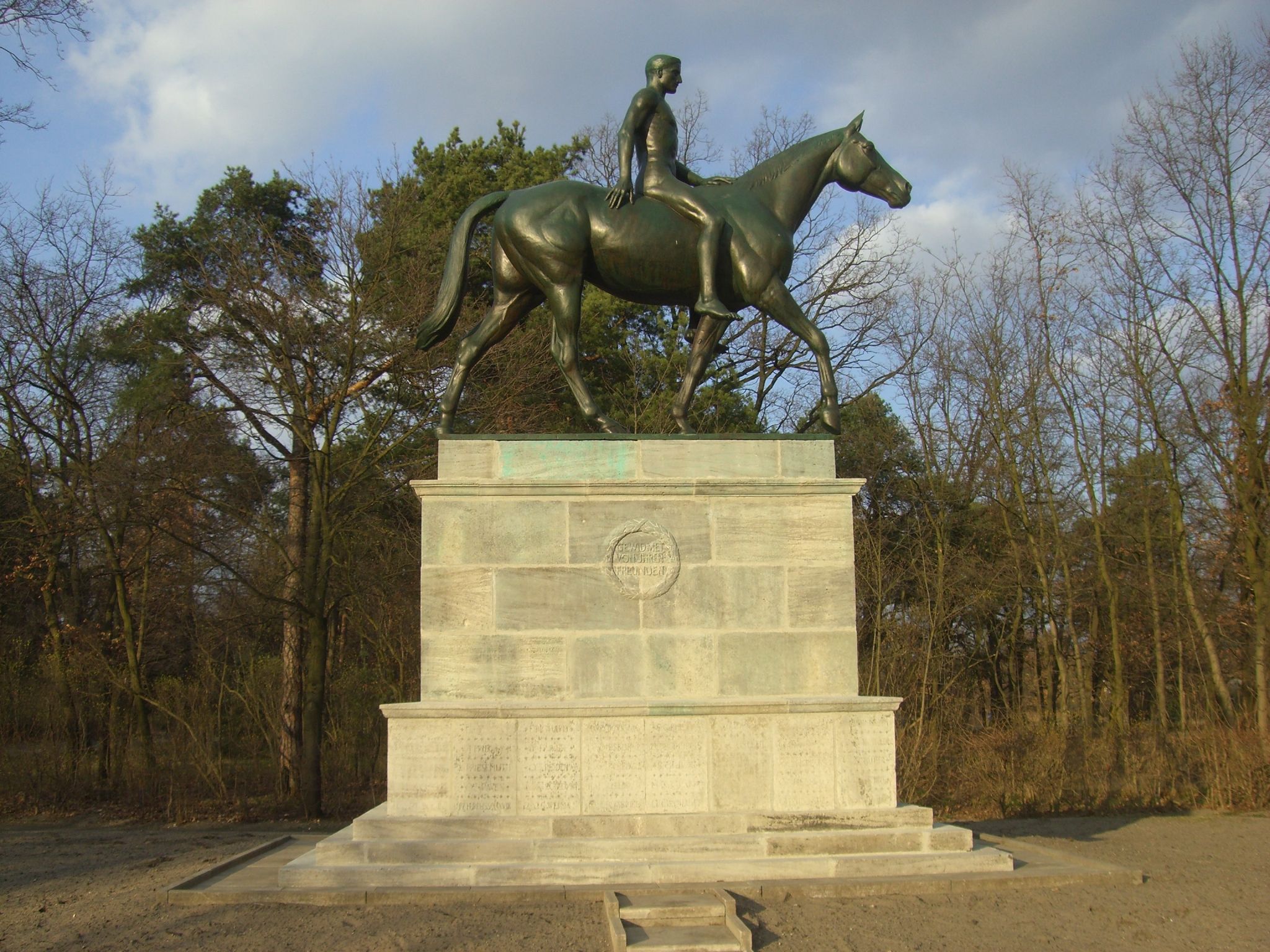 Photographer: Martina Rohde 2008 | Place | Berlin Karlshorst Gelände der Trabrennbahn WK 1 |
| District | Berlin Lichtenberg | |
| GOV-ID | KARRSTJO62SL | |
| Belongs to cemetery | ||
 Photographer: | Belongs to church | |
| Longitude and latitude | °O °N | |
| Numbber of fallen | 130 | |
| Remarks | Reiterstandbild von Willibald Fritsch für 22 Berufsreiter und 139 Herrenreiter, gefallen im 1. WK, Grundsteinlegung 1924, Einweihung 1925, 2006 sehr schlechter Zustand. Die Namen auf dem Sockel wurden nach 1945, wahrscheinlich in den 70er Jahren, unkenntlich gemacht. Das Denkmal wurde inzwischen wieder saniert, die Inschriften und auch die Namen soweit möglich wieder sichtbar gemacht, wobei die Lesbarkeit der Namen durch die frühere Verspachtelung leider gelitten hat. Die Namensliste ist nicht vollständig (entnommen einer Broschüre zum 100 Jahrestag der Rennbahn Karlshorst).
Inschriften:
Vorne: Hinten: | |
| Entry 1 to 50 of 130 entries |  |
|||
| Lastname | Firstname | |
| Ackermann | Gerhard |
| Auer von herrenkirchen | Helmuth |
| Barckhausen | Oskar |
| Berner | |
| Bock von wülfingen | J. |
| Boehmer | Franz |
| Brandhorst-satzkorn | |
| Braun | J. |
| Correvon | Charles |
| Demnig | |
| Dietzsch | |
| Douglas | Harry |
| Euen | Eberhard |
| Evmann | |
| Frhr. knigge | |
| Frhr. ostman von der leye | |
| Frhr. tucher von simmelsdorf | |
| Frhr. von bellersheim | |
| Frhr. von brenken | |
| Frhr. von d. bussche-streithorst | Carl |
| Frhr. von esebeck | H. A. |
| Frhr. von guttenberg | |
| Frhr. von hadeln | |
| Frhr. von schlotheim | |
| Frhr. von seckendorff | |
| Frhr. von wangenheim | Friedrich |
| Frhr. von wangenheim | Max |
| Gabriel | |
| Geisler | E. |
| George | |
| Giulini | E. |
| Godeffroy-färber | C. |
| Gräff | Leo |
| Graeff | Max |
| Graf hardenberg | |
| Graf holck | Erich |
| Graf königsmarck | W. |
| Graf kanitz | |
| Graf kayserlingk | A. |
| Graf strachwitz | |
| Graf von bethusy-huc | E. |
| Graf von bethusy-huc | Waldemar |
| Graf von westarp | Georg |
| Groeger | |
| Gudowius | W. |
| Höpker | E. |
| Hallström | F. |
| Harlan | |
| Heinsius | O. |
| Hellwig | A. |
Verein für Computergenealogie e.V.
| Name: | |
| GOV-ID: | KARRSTJO62SL |
| Longitude and Latitude: | 13.5258 °O 52.4825 °N |
| Height over NN |
Back to overview