Directory of memorials to war dead and war gravesites
The Brandenburg register of memorials to fallen soldiers and war gravesites is an open project of the Brandenburg Genealogical Society "Roter Adler" e.V. Not only members of the society but also all other interested parties can participate. In this project, which is affiliated to the cemeteries as well as to the villages, monuments for fallen soldiers as well as war gravesites and the data to be found on them are to be recorded. It does not matter whether they are located in a cemetery or any other place in the village.
Each sender of data can decide for himself whether the transcripts are to be displayed completely publicly or only as an index of names. The symbols behind the war memorials and war gravesites have the following meaning: The transcripts for these entries can be viewed completely publicly./em>
 Information on these fallen soldiers or graves can be requested by e-mail
Currently this directory contains information on 1191 war memorials and war gravesites.
Fürstenwalde / Spree Kriegsgräberstätte Waldfriedhof WK 2
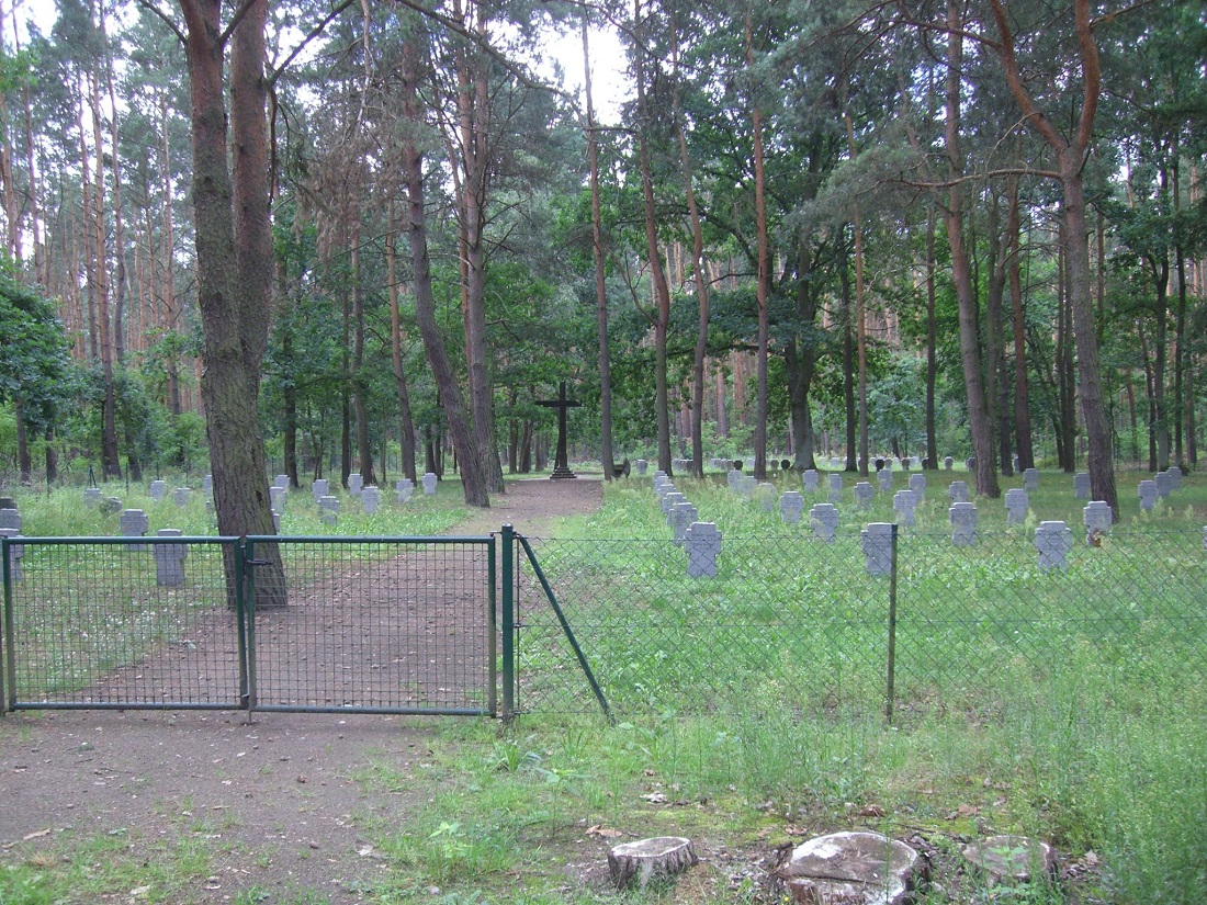 Photographer: Martina Rohde 2008 | Place | Fürstenwalde / Spree Kriegsgräberstätte Waldfriedhof WK 2 |
| District | Landkreis Oder-Spree | |
| GOV-ID | WALLDEJO72AJ | |
| Belongs to cemetery | Fürstenwalde Waldfriedhof (Kriegsgräberstätte) | |
 Photographer: | Belongs to church | |
| Longitude and latitude | °O °N | |
| Numbber of fallen | 637 | |
| Remarks | Reiner Kriegsgräberfriedhof, 12 Reihen mit insgesamt 116 Kreuzen, doppelseitig mit meist je 3 Namen beschriftet, in der Mitte ein großes Holzkreuz ohne Inschrift, Name auch „Friedhof im Pintsch-Gelände“; lt. Angaben des Volksbund zum Friedhof wahrsch. hauptsächlich Verstorbene aus dem Lazarett. | |
| Entry 1 to 50 of 637 entries |  |
|||
| Lastname | Firstname | |
| Abraham | Paul |
| Adam | Paul |
| Ahlgrimm | Hans |
| Ahrendt | Hans |
| Albert | Eugen |
| Albrecht | Wilhelm |
| Altendorf | Arthur |
| Amberg | Friedrich |
| Anderst | Anton |
| Anklam | Hans |
| Ansorg | Erich |
| Arendt | Horst |
| Arlt | Hans |
| Aschermann | Emil |
| Böhm | Wilhelm |
| Böhm | Wilhelm |
| Börner | Paul |
| Börsting | Karl |
| Büdel | Hans |
| Bünnige | Fritz |
| Babl | Franz |
| Bache | Günter |
| Bahr | Hermann |
| Balko | Heinrich |
| Bandorf | Helmut |
| Baron | Richard |
| Barzog | Bernhard |
| Baumann | Hans |
| Beck | Hermann |
| Becker | Johannes |
| Bednarek | Stanislaus |
| Begemann | Erwin |
| Behling | Emma |
| Beier | August |
| Berger | Paul |
| Bergh | Heinrich v. d. |
| Bernhagen | Else |
| Beuthner | Richard |
| Bickel | Robert |
| Birnstein | Georg |
| Blabsreiter | Martin |
| Blasek | Emil |
| Bleich | Emil |
| Block | Karl |
| Block | Alfred |
| Blumberg | Heinz |
| Bogh | Friedrich |
| Bolender | Adam |
| Bonn | Willi |
| Boos | Artur |
Verein für Computergenealogie e.V.
| Name: | Waldfriedhof (Kriegsgräberstätte) Fürstenwalde |
| GOV-ID: | WALLDEJO72AJ |
| Longitude and Latitude: | 14.0446 °O 52.37635 °N |
| Height over NN |
Back to overview