Directory of memorials to war dead and war gravesites
The Brandenburg register of memorials to fallen soldiers and war gravesites is an open project of the Brandenburg Genealogical Society "Roter Adler" e.V. Not only members of the society but also all other interested parties can participate. In this project, which is affiliated to the cemeteries as well as to the villages, monuments for fallen soldiers as well as war gravesites and the data to be found on them are to be recorded. It does not matter whether they are located in a cemetery or any other place in the village.
Each sender of data can decide for himself whether the transcripts are to be displayed completely publicly or only as an index of names. The symbols behind the war memorials and war gravesites have the following meaning: The transcripts for these entries can be viewed completely publicly./em>
 Information on these fallen soldiers or graves can be requested by e-mail
Currently this directory contains information on 1188 war memorials and war gravesites.
Blumberg (OT von Casekow) (Uckermark)
 Photographer: Jörg Schnadt Februar 2017 | Place | Blumberg (OT von Casekow) (Uckermark) |
| District | Landkreis Uckermark | |
| GOV-ID | BLUER1JO73BE | |
| Belongs to cemetery | ||
 Photographer: | Belongs to church | Blumberg (OT von Casekow) (Uckermark) |
| Longitude and latitude | °O °N | |
| Numbber of fallen | 1 | |
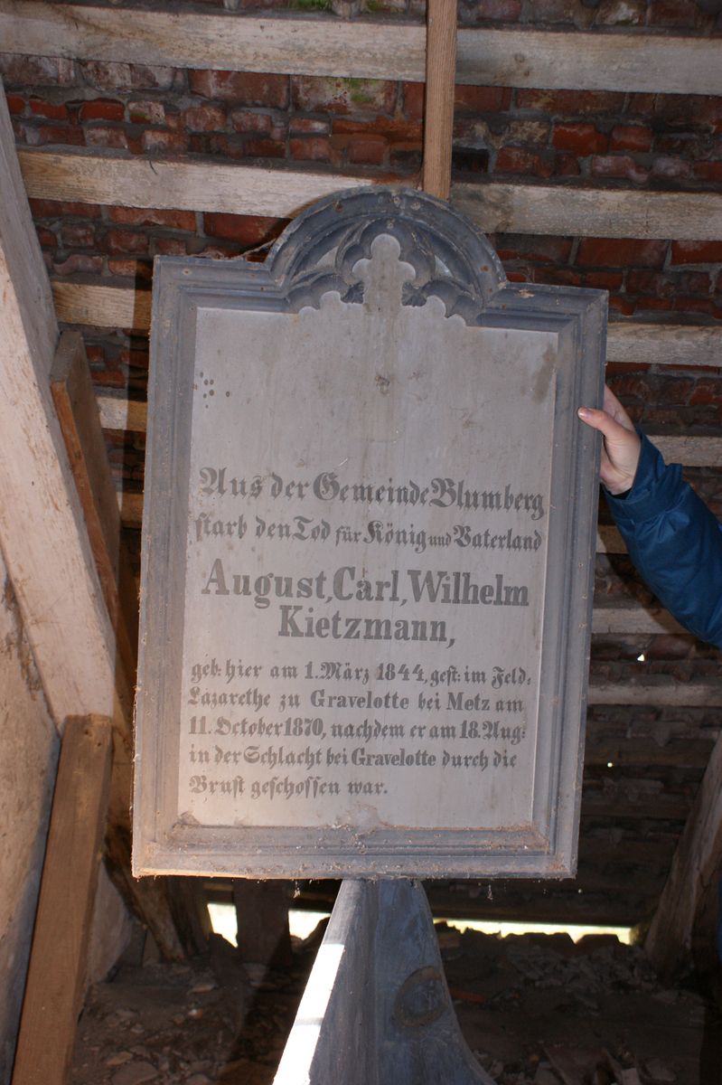
| Remarks | Völlig ungeschützt ist unter dem Kirchendach eine Gedenktafel für einen 1870 Gefallenen abgestellt.
Inschrift: Aus der Gemeinde Blumberg starb den Tod für König und Vaterland August Carl Wilhelm Kietzmann geb. hier am 1. März 1844, gest. im Feld-Lazarethe zu Gravelotte bei Metz am 11. October 1870, nachdem er am 18. Aug. in der Schlacht bei Gravelotte durch die Brust geschossen war. | |
| Lastname | Firstname | |
| Kietzmann | August Carl Wilhelm |
Verein für Computergenealogie e.V.
| Name: | Blumberg |
| GOV-ID: | BLUER1JO73BE |
| Longitude and Latitude: | 14.1519 °O 53.2069 °N |
| Height over NN |
Back to overview